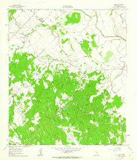
1960 Map of Snook
USGS Topo · Published 1962About this map
The agrarian community of Snook serves as the focal point of this Burleson County survey, characterized by its network of rural churches and schoolhouses. Settled patterns of the early 1960s are visible through the proximity of the Czech Ch and Snook Cem to the town center, while smaller outposts like Merle and Little Flock dot the landscape. The terrain is defined by a dense system of waterways, including Davidson Creek and the meandering Old River, which once dictated the movement of goods and people across these Texas plains.
Find a feature on this map
33 named features on this map. Tap any name to fly to it.
Don’t see what you’re looking for? This feature index may not catch every label — zoom into the map to look around manually.
Map Details
Editions of this 1960 Snook Map
2 editions found
Other maps of this area

1914 · Gay Hill
USGS Topo · 1:62,500

1954 · Austin
USGS Topo · 1:250,000

1956 · Bryan
USGS Topo · 1:62,500

1956 · Caldwell
USGS Topo · 1:62,500

1956 · Somerville
USGS Topo · 1:62,500

1959 · Gay Hill
USGS Topo · 1:24,000

1959 · Clay
USGS Topo · 1:24,000

1959 · Somerville
USGS Topo · 1:24,000

1959 · Independence
USGS Topo · 1:24,000

1960 · Lyons
USGS Topo · 1:24,000