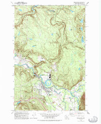
1993 Map of Snoqualmie
USGS Topo · Published 1993About this map
The industrial and natural landscape of the Snoqualmie Valley is centered around the massive Lumber Mill and the power generation complex at Snoqualmie Falls. This 1993 revision, based on photography from the 1950s through the 1980s, captures the confluence of the South Fork, Middle Fork, and North Fork of the Snoqualmie River. The map details the transition from timber and power operations to residential growth in settlements like Snoqualmie and North Bend.
Find a feature on this map
47 named features on this map. Tap any name to fly to it.
Don’t see what you’re looking for? This feature index may not catch every label — zoom into the map to look around manually.
Map Details
Editions of this 1993 Snoqualmie Map
This is the sole edition of this map. No revisions or reprints were ever made.
Other maps of this area

1913 · Cedar Lake
USGS Topo · 1:125,000

1921 · Sultan
USGS Topo · 1:125,000

1923 · Sultan
USGS Topo · 1:125,000

1953 · Snoqualmie
USGS Topo · 1:24,000

1953 · North Bend
USGS Topo · 1:24,000

1953 · Lake Joy
USGS Topo · 1:24,000

1953 · Hobart
USGS Topo · 1:24,000

1953 · Fall City
USGS Topo · 1:24,000

1953 · Carnation
USGS Topo · 1:24,000

1957 · Wenatchee
USGS Topo · 1:250,000