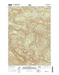
2017 Map of Snow Peak
USGS Topo · Published 2017About this map
Jordan Valley sits along the northern reaches of this Marion County landscape, where the foothills begin their steep ascent toward the Cascades. The geography is defined by a dense network of drainages, most notably Thomas Creek, which wind through the timbered heights and valleys. To the south, the terrain rises significantly toward Snow Peak, a prominent landmark that overlooks the headwaters of numerous streams including Bilyeu Cr and the Roaring River.
Find a feature on this map
32 named features on this map. Tap any name to fly to it.
Don’t see what you’re looking for? This feature index may not catch every label — zoom into the map to look around manually.
Map Details
Editions of this 2017 Snow Peak Map
This is the sole edition of this map. No revisions or reprints were ever made.
Other maps of this area

1929 · Mill City
USGS Topo · 1:125,000

1951 · Lyons
USGS Topo · 1:62,500

1951 · Snow Peak
USGS Topo · 1:62,500

1953 · Salem
USGS Topo · 1:250,000

1954 · Salem
USGS Topo · 1:250,000

1955 · Mill City
USGS Topo · 1:62,500

1956 · Quartzville
USGS Topo · 1:62,500

1960 · Salem
USGS Topo · 1:250,000

1962 · Salem
USGS Topo · 1:250,000

1963 · Salem
USGS Topo · 1:250,000