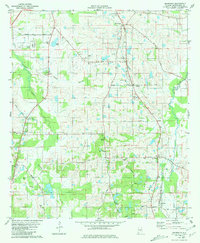
1981 Map of Snowdoun
USGS Topo · Published 1981About this map
The Seaboard Coast Line defines the corridor of this landscape south of Montgomery, Alabama, connecting a series of rural hamlets including Snowdoun, Tharin, and Sprague. The terrain is shaped by the winding course of Pintlalla Creek and Ramer Creek, creating a rural pattern where family-named roads like Mc Gehee Road and Butler Mill Road link dispersed homesteads and community centers. Genealogists will find a wealth of specific landmarks, from the clusters of graves at Woodland Hills Cem and Shackelford Cem to the local congregations at Beulah Ch and Providence Ch. The presence of features such as Lake Edna and various radio facilities underscores the mid-century evolution of this agricultural area as it balanced traditional land use with modern infrastructure.
Find a feature on this map
42 named features on this map. Tap any name to fly to it.
Don’t see what you’re looking for? This feature index may not catch every label — zoom into the map to look around manually.
Map Details
Editions of this 1981 Snowdoun Map
2 editions found
Other maps of this area

1927 · Montgomery
USGS Topo · 1:48,000

1930 · Montgomery
USGS Topo · 1:62,500

1953 · Montgomery
USGS Topo · 1:250,000

1956 · Montgomery
USGS Topo · 1:250,000

1957 · Montgomery
USGS Topo · 1:250,000

1957 · Letohatchee
USGS Topo · 1:62,500

1958 · Montgomery
USGS Topo · 1:62,500

1958 · Montgomery South
USGS Topo · 1:24,000

1958 · Mount Meigs
USGS Topo · 1:62,500

1971 · Davis Crossroads
USGS Topo · 1:24,000