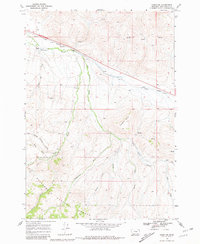
1968 Map of Snowline
USGS Topo · Published 1981About this map
The Union Pacific railroad corridor defines the northern valley of this high-altitude landscape, where the trackage passes the Snowline Ranch and the eponymous Snowline station. The geography is characterized by an intricate drainage system feeding into the Beaver Creek valley, with numerous named tributaries such as Shineberger Creek, Swamp Creek, and Middle Creek carving through the southern foothills.
Find a feature on this map
30 named features on this map. Tap any name to fly to it.
Don’t see what you’re looking for? This feature index may not catch every label — zoom into the map to look around manually.
Map Details
Editions of this 1968 Snowline Map
3 editions found
Other maps of this area

1955 · Dubois
USGS Topo · 1:250,000

1957 · Paul Reservoir
USGS Topo · 1:62,500

1957 · Edie Ranch
USGS Topo · 1:62,500

1958 · Dubois
USGS Topo · 1:250,000

1965 · Lima
USGS Topo · 1:24,000

1965 · Lima Peaks
USGS Topo · 1:24,000

1968 · Lima Dam
USGS Topo · 1:24,000

1968 · Snowline
USGS Topo · 1:24,000

1968 · Monida
USGS Topo · 1:24,000

1968 · Henry Gulch
USGS Topo · 1:24,000