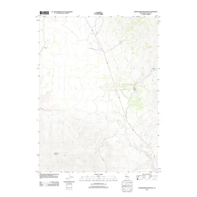
2012 Map of Snowstorm Mountain
USGS Topo · Published 2012About this map
Snowstorm Mountain anchors this high-elevation landscape in Lassen County, where water sources like Spanish Springs and Rye Ranch Spring define the geography of the high desert. The 2012 survey illustrates a sparsely populated region dominated by seasonal usage and remote access points such as the Ramhorn Campground on the eastern edge. A network of rural routes, including Horse Lake Rd and Spanish Springs Rd, connects the higher elevations at Crest to the drainage basins below. The drainage pattern is marked by the winding path of Secret Cr, which flows through the center of the quadrangle, and the significant geological formation of Rye Patch Canyon. This map provides a clear record of the area's modern infrastructure and natural resources, essential for understanding the land management and transit patterns in this part of California.
Find a feature on this map
13 named features on this map. Tap any name to fly to it.
Don’t see what you’re looking for? This feature index may not catch every label — zoom into the map to look around manually.
Map Details
Editions of this 2012 Snowstorm Mountain Map
This is the sole edition of this map. No revisions or reprints were ever made.
Other maps of this area

1886 · Honey Lake
USGS Topo · 1:250,000

1891 · Honey Lake
USGS Topo · 1:250,000

1893 · Honey Lake
USGS Topo · 1:250,000

1954 · Observation Peak
USGS Topo · 1:62,500

1954 · Karlo
USGS Topo · 1:62,500

1954 · Ravendale
USGS Topo · 1:62,500

1954 · Shinn Mountain
USGS Topo · 1:62,500

1955 · Westwood
USGS Topo · 1:250,000

1958 · Westwood
USGS Topo · 1:250,000

1959 · Westwood
USGS Topo · 1:250,000