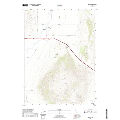
2020 Map of Snowville
USGS Topo · Published 2020About this map
Snowville serves as the central hub of this Northern Utah landscape, positioned where the expansive Curlew Valley meets the rising elevations of the Hansel Mountains. The town's grid is anchored by W Main St and E Main St, with the local Po and the Snowville Cem providing important touchpoints for genealogical research and local history. The high desert terrain is defined by dramatic shifts in elevation, from the level expanse of Calf Flat to the steep relief of Big Canyon. Drainage for the region is primarily handled by the winding course of Deep Cr, which flows southward through the valley floor. To the southeast, the terrain descends into Hansel Valley, while a network of rural routes like Locomotive Springs Rd and Dairy Rd connect the scattered agricultural and ranching interests that characterize this portion of Box Elder County.
Find a feature on this map
30 named features on this map. Tap any name to fly to it.
Don’t see what you’re looking for? This feature index may not catch every label — zoom into the map to look around manually.
Map Details
Editions of this 2020 Snowville Map
This is the sole edition of this map. No revisions or reprints were ever made.
Other maps of this area

1954 · Pocatello
USGS Topo · 1:250,000

1954 · Brigham City
USGS Topo · 1:250,000

1958 · Pocatello
USGS Topo · 1:250,000

1958 · Brigham City
USGS Topo · 1:250,000

1962 · Brigham City
USGS Topo · 1:250,000

1968 · Salt Wells
USGS Topo · 1:24,000

1968 · Rattlesnake Pass
USGS Topo · 1:24,000

1968 · Snowville
USGS Topo · 1:24,000
1968 · Bulls Pass
USGS Topo · 1:24,000

1968 · Monument Peak
USGS Topo · 1:24,000