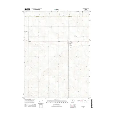
2014 Map of Snyder
USGS Topo · Published 2014About this map
The village of Snyder serves as the primary hub of this eastern Nebraska landscape, situated along the path of Highway 91. The map reveals a structured grid of rural section roads, such as A Rd and 9th Rd, that define the agricultural character of the region. Local history is anchored by the presence of Saint Wenceslaus Cem in the northwest and the Snyder Cem just north of the village. The drainage of Pebble Cr meanders through the northeast, providing a natural break in the otherwise orderly farm plots. Within the village itself, the residential layout is clearly defined by streets like Range Line St and Ash St, illustrating the concentrated development of this small prairie community at the time of the survey.
Find a feature on this map
27 named features on this map. Tap any name to fly to it.
Don’t see what you’re looking for? This feature index may not catch every label — zoom into the map to look around manually.
Map Details
Editions of this 2014 Snyder Map
This is the sole edition of this map. No revisions or reprints were ever made.
Other maps of this area

1955 · Fremont
USGS Topo · 1:250,000

1957 · Fremont
USGS Topo · 1:250,000

1958 · Fremont
USGS Topo · 1:250,000

1966 · Scribner SW
USGS Topo · 1:24,000

1966 · Monterey
USGS Topo · 1:24,000

1966 · Webster
USGS Topo · 1:24,000

1966 · Snyder
USGS Topo · 1:24,000

1966 · Aloys
USGS Topo · 1:24,000

1966 · Scribner
USGS Topo · 1:24,000
1966 · West Point
USGS Topo · 1:24,000