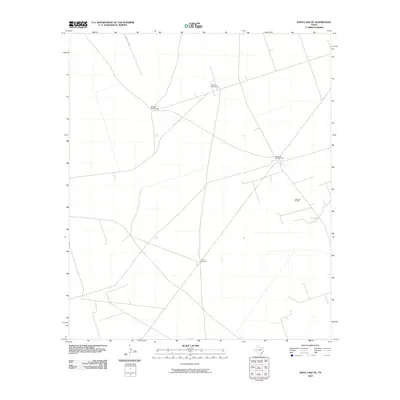
2010 Map of Soda Lake NE
USGS Topo · Published 2010About this map
The Little Joe Oil Field and a network of livestock infrastructure define this area of the Permian Basin as it appeared during the late 2000s. The landscape is characterized by the sparse, functional marks of West Texas ranching and resource extraction, connected by a web of local roads and paths including M Cattle Co Rd. Scattered across the terrain are several named watering points essential for cattle operations, such as Windmill Number Two, Windmill NumberThree, and Windmill Number Four. The presence of the China Windmill further illustrates the reliance on groundwater in this arid environment. This survey captures a specific moment in the industrial and agricultural life of the region, where oil production and ranching coexist across a vast, open expanse.
Find a feature on this map
6 named features on this map. Tap any name to fly to it.
Don’t see what you’re looking for? This feature index may not catch every label — zoom into the map to look around manually.
Map Details
Editions of this 2010 Soda Lake NE Map
This is the sole edition of this map. No revisions or reprints were ever made.
Other maps of this area

1954 · Pecos
USGS Topo · 1:250,000

1957 · Pecos
USGS Topo · 1:250,000

1961 · Soda Lake
USGS Topo · 1:24,000

1967 · Soda Lake NW
USGS Topo · 1:24,000

1968 · Soda Lake SE
USGS Topo · 1:24,000

1968 · Wink South
USGS Topo · 1:24,000

1968 · Soda Lake NE
USGS Topo · 1:24,000
1969 · Pyote West
USGS Topo · 1:24,000

1969 · Cheyenne Draw SW
USGS Topo · 1:24,000

1970 · Wink North
USGS Topo · 1:24,000