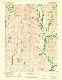
1964 Map of Soldier Creek SW
USGS Topo · Published 1965About this map
The Potawatomi Indian Reservation Boundary bisects this Kansas landscape, defining the administrative and cultural geography of Jackson County in the mid-1960s. The terrain is characterized by the intricate drainage systems of Soldier Creek and its tributaries, including the South Branch and James Creek. These watercourses carve through the townships of Adrian, Lincoln, and Washington, where rural life is anchored by small-scale landmarks like High Prairie Sch and Our Lady of the Snows Ch.
Find a feature on this map
17 named features on this map. Tap any name to fly to it.
Don’t see what you’re looking for? This feature index may not catch every label — zoom into the map to look around manually.
Map Details
Editions of this 1964 Soldier Creek SW Map
2 editions found
Other maps of this area

1889 · Wamego
USGS Topo · 1:125,000

1889 · Topeka
USGS Topo · 1:125,000

1894 · Topeka
USGS Topo · 1:125,000

1894 · Wamego
USGS Topo · 1:125,000

1950 · Kansas City
USGS Topo · 1:250,000

1952 · Rossville
USGS Topo · 1:24,000

1952 · Grove
USGS Topo · 1:24,000

1953 · St Marys
USGS Topo · 1:24,000

1954 · Kansas City
USGS Topo · 1:250,000

1955 · Manhattan
USGS Topo · 1:250,000