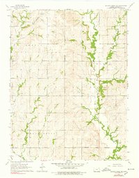
1964 Map of Soldier Creek SW
USGS Topo · Published 1978About this map
The Potawatomi Indian Reservation Boundary bisects this Kansas landscape, defining the administrative and cultural geography of the region in the mid-1960s. This rural expanse is marked by a network of creeks, including the winding Soldier Creek and its South Branch, which drain the undulating terrain. Small community hubs are anchored by local landmarks such as Our Lady of the Snows Ch and High Prairie Sch, reflecting the traditional social centers of Jackson County's townships like Adrian and Lincoln. In the southern portion of the map, the Union Pacific railroad cuts through the countryside near Delia Cem, illustrating the vital transportation link that connected these farming communities to broader markets. Several family and community burial grounds, including Shields Cem and Dampground Cem, are scattered across the landscape, providing essential touchpoints for genealogical research and local history.
Find a feature on this map
17 named features on this map. Tap any name to fly to it.
Don’t see what you’re looking for? This feature index may not catch every label — zoom into the map to look around manually.
Map Details
Editions of this 1964 Soldier Creek SW Map
2 editions found
Other maps of this area

1889 · Wamego
USGS Topo · 1:125,000

1889 · Topeka
USGS Topo · 1:125,000

1894 · Topeka
USGS Topo · 1:125,000

1894 · Wamego
USGS Topo · 1:125,000

1950 · Kansas City
USGS Topo · 1:250,000

1952 · Rossville
USGS Topo · 1:24,000

1952 · Grove
USGS Topo · 1:24,000

1953 · St Marys
USGS Topo · 1:24,000

1954 · Kansas City
USGS Topo · 1:250,000

1955 · Manhattan
USGS Topo · 1:250,000