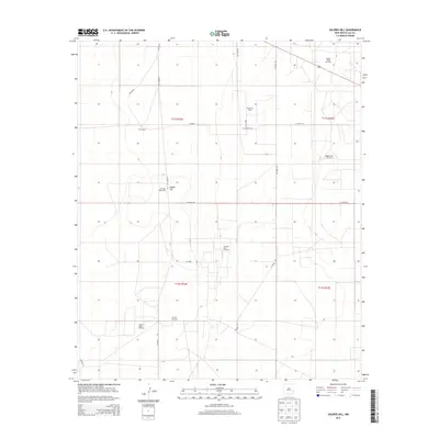
2013 Map of Soldier Hill
USGS Topo · Published 2013About this map
Fort Ranch and other large livestock operations define this portion of Lea County, where ranching traditions meet the infrastructure of the modern energy industry. The landscape is marked by the presence of numerous petroleum developments, including the Bagley North Oil Field, Bagley West Oil Field, and several tracts of the Caprock East Oil Field. These industrial sites are interconnected by a geometric grid of county roads such as Co Road 157 and Co Road 158, which cut across the high plains.
Find a feature on this map
25 named features on this map. Tap any name to fly to it.
Don’t see what you’re looking for? This feature index may not catch every label — zoom into the map to look around manually.
Map Details
Editions of this 2013 Soldier Hill Map
This is the sole edition of this map. No revisions or reprints were ever made.
Other maps of this area

1954 · Brownfield
USGS Topo · 1:250,000

1958 · Brownfield
USGS Topo · 1:250,000

1962 · Brownfield
USGS Topo · 1:250,000

1973 · Mescalero Point
USGS Topo · 1:24,000

1973 · Soldier Hill
USGS Topo · 1:24,000

1973 · Caprock
USGS Topo · 1:24,000

1973 · Caudill Ranch
USGS Topo · 1:24,000

1973 · Cooper-Good Ranch
USGS Topo · 1:24,000

1973 · Mescalero Point NE
USGS Topo · 1:24,000
1973 · Frier Ranch
USGS Topo · 1:24,000