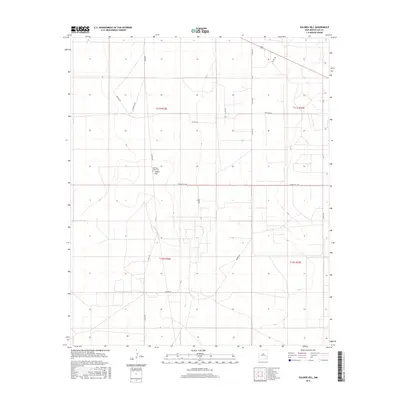
2017 Map of Soldier Hill
USGS Topo · Published 2017About this map
Old New Hope Cem sits at the heart of this Lea County landscape, a significant site for genealogists and local historians tracing early roots in this part of New Mexico. The area is defined by a grid of rural routes and ranch roads, including Soldier Hill Rd and Grose Rd, which connect the settlement of Soldier Hill to the surrounding sections. The terrain is structured by township and range boundaries such as t11s r32e and t12s r32e, reflecting the systematic Bureau of Land Management survey of the American West. The road network, featuring distinctive paths like Eclipse Rd and Eclipse Loop, illustrates the modern connectivity of this high plains region, while other routes like Moore Rd and Mathers Rd facilitate movement across the agricultural and ranching interior.
Find a feature on this map
19 named features on this map. Tap any name to fly to it.
Don’t see what you’re looking for? This feature index may not catch every label — zoom into the map to look around manually.
Map Details
Editions of this 2017 Soldier Hill Map
This is the sole edition of this map. No revisions or reprints were ever made.
Other maps of this area

1954 · Brownfield
USGS Topo · 1:250,000

1958 · Brownfield
USGS Topo · 1:250,000

1962 · Brownfield
USGS Topo · 1:250,000

1973 · Mescalero Point
USGS Topo · 1:24,000

1973 · Soldier Hill
USGS Topo · 1:24,000

1973 · Caprock
USGS Topo · 1:24,000

1973 · Caudill Ranch
USGS Topo · 1:24,000

1973 · Cooper-Good Ranch
USGS Topo · 1:24,000

1973 · Mescalero Point NE
USGS Topo · 1:24,000
1973 · Frier Ranch
USGS Topo · 1:24,000