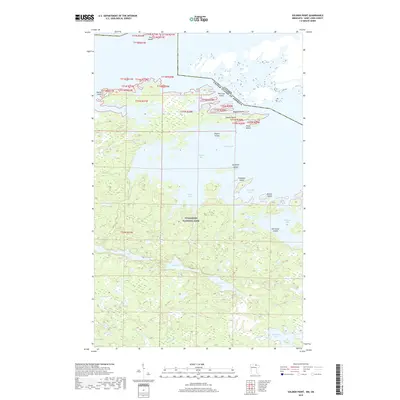
2019 Map of Soldier Point
USGS Topo · Published 2019About this map
Voyageurs National Park encompasses the majority of this borderland terrain, where the international boundary between the United States of America and Canada threads through the waters of Rainy Lake. The landscape is a complex network of island-dotted bays and interior freshwater basins, connected by narrow channels like Brule Narrows. The intricate shoreline is punctuated by prominent landforms such as Soldier Point and Gaylord Point, which guard the entrance to the sprawling Saginaw Bay. South of the main lake, a series of more isolated water bodies including Locator Lake, Quill Lake, and Shoepack Lake sit among the dense interior forests. This map illustrates the vital importance of water navigation in the region, where named features like Marion Bay and Lost Bay suggest the intricate geography known well by those who frequent these northern waters.
Find a feature on this map
30 named features on this map. Tap any name to fly to it.
Don’t see what you’re looking for? This feature index may not catch every label — zoom into the map to look around manually.
Map Details
Editions of this 2019 Soldier Point Map
This is the sole edition of this map. No revisions or reprints were ever made.
Other maps of this area

1954 · International Falls
USGS Topo · 1:250,000

1957 · International Falls
USGS Topo · 1:250,000

1958 · International Falls
USGS Topo · 1:250,000

1967 · Kempton Bay
USGS Topo · 1:24,000

1968 · Soldier Point
USGS Topo · 1:24,000

1968 · Daley Bay
USGS Topo · 1:24,000

1968 · Ash River NE
USGS Topo · 1:24,000

1969 · Cranberry Bay
USGS Topo · 1:24,000

1969 · Kabetogama
USGS Topo · 1:24,000
1978 · International Falls
USGS Topo · 1:100,000