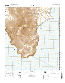
2014 Map of Solomon B-3 NE
USGS Topo · Published 2014About this map
Iknutak Mountain dominates the center of this coastal landscape, providing a topographical anchor for the surrounding drainages. Along the southern edge, Rocky Point juts into the waters of Norton Sound, marking a prominent landmark for local navigation and coastal history. The area's hydrology is characterized by Bungshefoot Cr, which winds through the terrain toward the eastern shoreline. The map also captures the western reach of Golovnin Bay, illustrating the transition from the high elevation of the interior peaks down to the sheltered saltwater inlets of this Seward Peninsula region. The sparse distribution of named features underscores the primary role of the natural landforms and traditional maritime routes in this part of Alaska.
Find a feature on this map
9 named features on this map. Tap any name to fly to it.
Don’t see what you’re looking for? This feature index may not catch every label — zoom into the map to look around manually.
Map Details
Editions of this 2014 Solomon B-3 NE Map
This is the sole edition of this map. No revisions or reprints were ever made.
Other maps of this area

1950 · Solomon B-3
USGS Topo · 1:63,360

1950 · Solomon B-2
USGS Topo · 1:63,360

1950 · Solomon C-2
USGS Topo · 1:63,360

1950 · Solomon
USGS Topo · 1:250,000

1950 · Solomon C-3
USGS Topo · 1:63,360

1951 · Solomon
USGS Topo · 1:250,000

2014 · Solomon C-3 SE
USGS Topo · 1:25,000

2014 · Solomon B-2 NW
USGS Topo · 1:25,000
2014 · Solomon B-3 NW
USGS Topo · 1:25,000
2014 · Solomon C-2 SW
USGS Topo · 1:25,000