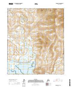
2017 Map of Solomon C-3 NE
USGS Topo · Published 2017About this map
Norton Sound defines the southern edge of this coastal landscape on the Seward Peninsula. The terrain is characterized by a dense network of watercourses and wetlands, where the Yuonglik River and Mudyutok River meander through low-lying flats before reaching the sea. To the east, the Kachauik River drains the higher elevations, where the map reveals a complex topography of ridges and valleys. This 2017 survey illustrates the untouched natural drainage patterns of this subarctic region, showing how these waterways shape the geography of the peninsula far from established settlements.
Find a feature on this map
12 named features on this map. Tap any name to fly to it.
Don’t see what you’re looking for? This feature index may not catch every label — zoom into the map to look around manually.
Map Details
Editions of this 2017 Solomon C-3 NE Map
This is the sole edition of this map. No revisions or reprints were ever made.
Other maps of this area

1950 · Solomon D-2
USGS Topo · 1:63,360

1950 · Solomon C-2
USGS Topo · 1:63,360

1950 · Solomon D-3
USGS Topo · 1:63,360

1950 · Solomon
USGS Topo · 1:250,000

1950 · Solomon C-3
USGS Topo · 1:63,360

1951 · Solomon
USGS Topo · 1:250,000

2014 · Solomon C-3 SE
USGS Topo · 1:25,000
2014 · Solomon C-2 NW
USGS Topo · 1:25,000
2014 · Solomon C-2 SW
USGS Topo · 1:25,000
2017 · Solomon D-2 SW
USGS Topo · 1:25,000