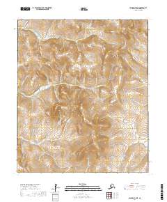
2017 Map of Solomon C-5 NE
USGS Topo · Published 2017About this map
The Klokerblok River and E Fork Solomon River wind through the interior of the Seward Peninsula in this 2017 survey. The landscape is defined by an intricate network of waterways named during the region's mining history, including the notable Big Hurrah Cr and its counterpart, Little Hurrah Cr. These names echo the gold rush era, reflecting the optimism and toil of early prospectors who worked these drainages. Access to this remote terrain is provided primarily by Council Road and Big Hurrah Road, which cut across the high ridges and valleys. Other family and descriptive names like Goldbottom Cr, Goodenough Cr, and Kentucky Cr suggest the specific locations of historic claims and activity centers that once dotted the peninsula's wilderness. The drainage patterns of Skookum River and Daisy Cr show the natural topography that dictated the movement of people and resources across this arctic landscape.
Find a feature on this map
37 named features on this map. Tap any name to fly to it.
Don’t see what you’re looking for? This feature index may not catch every label — zoom into the map to look around manually.
Map Details
Editions of this 2017 Solomon C-5 NE Map
This is the sole edition of this map. No revisions or reprints were ever made.
Other maps of this area

1907 · Casadepaga
USGS Topo · 1:62,500

1907 · Solomon
USGS Topo · 1:62,500

1950 · Solomon C-5
USGS Topo · 1:63,360

1950 · Solomon C-4
USGS Topo · 1:63,360

1950 · Solomon
USGS Topo · 1:250,000

1950 · Solomon D-4
USGS Topo · 1:63,360

1950 · Solomon D-5
USGS Topo · 1:63,360

1951 · Solomon
USGS Topo · 1:250,000
2017 · Solomon D-5 SW
USGS Topo · 1:25,000
2017 · Solomon D-5 SE
USGS Topo · 1:25,000