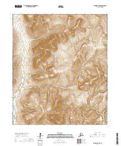
2017 Map of Solomon D-6 SW
USGS Topo · Published 2017About this map
The Seward Peninsula interior north of Nome reveals a landscape defined by an intricate network of waterways draining toward the Norton Sound. The Eldorado River dominates the western portion of the terrain, while the Bonanza River cuts through the southeastern corner. This 2017 survey details the hydrography of the region, where numerous small tributaries—often bearing the names of early prospectors or miners—feed the larger river systems. Notable among these are Kate and Anna Cr, San Francisco Cr, and Flickinger Cr. The drainage patterns, such as those of Venetia Cr and Gassman Cr, provide a clear picture of the watershed as it was documented in the early 21st century. The map serves as a precise record of the physical geography and established nomenclature within this part of the Nome Census Area.
Find a feature on this map
22 named features on this map. Tap any name to fly to it.
Don’t see what you’re looking for? This feature index may not catch every label — zoom into the map to look around manually.
Map Details
Editions of this 2017 Solomon D-6 SW Map
This is the sole edition of this map. No revisions or reprints were ever made.
Other maps of this area

1950 · Nome
USGS Topo · 1:250,000

1950 · Solomon C-6
USGS Topo · 1:63,360

1950 · Solomon
USGS Topo · 1:250,000

1950 · Solomon D-6
USGS Topo · 1:63,360

1950 · Nome D-1
USGS Topo · 1:63,360

1950 · Nome C-1
USGS Topo · 1:63,360

1951 · Nome
USGS Topo · 1:250,000

1951 · Solomon
USGS Topo · 1:250,000

1957 · Nome
USGS Topo · 1:250,000
1972 · Nome D-1
USGS Topo · 1:63,360