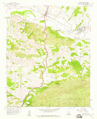
1959 Map of Solvang
USGS Topo · Published 1960About this map
Solvang and the historic Mission Santa Ines anchor this coastal valley survey, where the Santa Ynez River carves a path through the Purisima Hills and Santa Ynez Mountains. The landscape in the late 1950s is defined by sprawling cattle operations and agricultural holdings like Gardner Ranch, Alisal Ranch, and Folded Hills Ranch. South of the river, the terrain rises sharply toward Nojoqui Summit, a critical pass traversed by U.S. Route 101. This corridor connects the river valley to the coast through Cañada de la Gaviota, passing the small settlement at Las Cruces. The map captures the area just as modern tourism began to coalesce around the Danish-themed architecture of Solvang and natural landmarks like the cascades at Nojoqui Falls Park.
Find a feature on this map
50 named features on this map. Tap any name to fly to it.
Don’t see what you’re looking for? This feature index may not catch every label — zoom into the map to look around manually.
Map Details
Editions of this 1959 Solvang Map
4 editions found
Other maps of this area

1905 · Lompoc
USGS Topo · 1:125,000

1942 · Lompoc
USGS Topo · 1:125,000

1942 · Lompoc
USGS Topo · 1:62,500

1942 · Pt. Conception
USGS Topo · 1:62,500

1942 · Gaviota
USGS Topo · 1:62,500

1942 · Los Olivos
USGS Topo · 1:62,500

1943 · Los Olivos
USGS Topo · 1:62,500

1943 · Lompoc
USGS Topo · 1:125,000

1943 · Gaviota
USGS Topo · 1:62,500

1947 · Gaviota
USGS Topo · 1:62,500