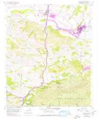
1959 Map of Solvang
USGS Topo · Published 1977About this map
Mission Santa Ines serves as the cultural anchor for Solvang, illustrating the area's transition from Spanish-era colonial history to mid-20th-century development. The landscape is defined by the Santa Ynez River valley, where agriculture and cattle ranching take center stage. Numerous family and operational landmarks such as Alisal Ranch, Gardner Ranch, and Las Cruces Ranch dot the hillsides, connected by a network of winding roads and jeep trails that ascend toward the Santa Ynez Mountains to the south.
Find a feature on this map
54 named features on this map. Tap any name to fly to it.
Don’t see what you’re looking for? This feature index may not catch every label — zoom into the map to look around manually.
Map Details
Editions of this 1959 Solvang Map
4 editions found
Other maps of this area

1905 · Lompoc
USGS Topo · 1:125,000

1942 · Lompoc
USGS Topo · 1:125,000

1942 · Lompoc
USGS Topo · 1:62,500

1942 · Pt. Conception
USGS Topo · 1:62,500

1942 · Gaviota
USGS Topo · 1:62,500

1942 · Los Olivos
USGS Topo · 1:62,500

1943 · Los Olivos
USGS Topo · 1:62,500

1943 · Lompoc
USGS Topo · 1:125,000

1943 · Gaviota
USGS Topo · 1:62,500

1947 · Gaviota
USGS Topo · 1:62,500