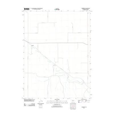
2011 Map of Somerset
USGS Topo · Published 2011About this map
Somerset occupies a central position on this Lincoln County landscape, situated where the high plains of Nebraska are dissected by the winding drainage of Medicine Creek. The area's character is defined by a sparse, grid-based network of roads that follow the township and section lines, many carrying names that likely reflect local family history such as S Darnell Rd and S Ash Grove Rd. The southern portion of the quadrangle is dominated by the convergence of the creek and its major tributary, Little Medicine Creek, which create natural breaks in the predominantly agricultural terrain. Historic transport routes are evidenced by the presence of S Wagon Trail Rd running along the western edge, indicating the enduring nature of old prairie paths as they transitioned into the modern county road system. This survey provides a clear look at the rural infrastructure of the early 21st century before modern expansion or changes to the local watercourses.
Find a feature on this map
14 named features on this map. Tap any name to fly to it.
Don’t see what you’re looking for? This feature index may not catch every label — zoom into the map to look around manually.
Map Details
Editions of this 2011 Somerset Map
This is the sole edition of this map. No revisions or reprints were ever made.
Other maps of this area

1954 · McCook
USGS Topo · 1:250,000

1956 · Wellfleet NW
USGS Topo · 1:24,000

1956 · White NE
USGS Topo · 1:24,000

1956 · Curtis NW
USGS Topo · 1:24,000

1956 · Dickens
USGS Topo · 1:24,000

1956 · Somerset
USGS Topo · 1:24,000

1956 · Wellfleet
USGS Topo · 1:24,000

1957 · McCook
USGS Topo · 1:250,000

1958 · McCook
USGS Topo · 1:250,000
1970 · Dickens NE
USGS Topo · 1:24,000