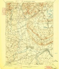
1898 Map of Somerville
USGS Topo · Published 1902About this map
Raritan River and its numerous branches dominate this late 19th-century landscape, illustrating the critical role of water for both transportation and power. In the southern portion of the sheet, the Water-Power Co's Raceway near Somerville highlights early industrial engineering alongside the Central Railroad of New Jersey. The map documents a dense network of established villages like Basking Ridge, Bernardsville, and Pottersville, connected by a complex system of rail lines including the Lehigh Valley Railroad and the Delaware Lackawanna and Western R. R. To the north, the terrain rises toward Mine Mtn. and Chimney Rock, while the eastern border follows the winding Passaic River through Millington and White Bridge. This survey captures the transition from a river-dependent economy to one increasingly shaped by the steam-powered connectivity of the regional rail hubs.
Find a feature on this map
97 named features on this map. Tap any name to fly to it.
Don’t see what you’re looking for? This feature index may not catch every label — zoom into the map to look around manually.
Map Details
Editions of this 1898 Somerville Map
2 editions found

Other maps of this area

1888 · Plainfield
USGS Topo · 1:62,500

1888 · Morristown
USGS Topo · 1:62,500

1888 · Hackettstown
USGS Topo · 1:62,500

1888 · New Brunswick
USGS Topo · 1:62,500

1888 · Princeton
USGS Topo · 1:62,500

1888 · Lake Hopatcong
USGS Topo · 1:62,500

1890 · High Bridge
USGS Topo · 1:62,500

1890 · Lambertville
USGS Topo · 1:62,500

1891 · Somerville
USGS Topo · 1:62,500

1891 · Lambertville
USGS Topo · 1:62,500
Featured Places
- Franklin Township, NJ
- Piscataway Township, NJ
- Bridgewater Township, NJ
- Hillsborough Township, NJ
- Readington Township, NJ