
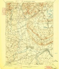
1898 Map of Somerville
USGS Topo · Published 1898About this map
Somerville and Raritan serve as the industrial and civic hubs of late nineteenth-century Somerset County, centered near the confluence of the Raritan River and the Millstone River. The presence of the Water Power Cos Raceway at Raritan highlights the era's reliance on hydraulic engineering for manufacturing. A dense network of transportation routes radiates from these centers, including the Central Railroad of New Jersey and the Philadelphia and Reading RR, which facilitate movement between rural outposts like Pluckemin and burgeoning residential areas such as Bernardsville. To the north, the terrain rises toward Mine Mtn., while the interior is defined by family-named hamlets and crossroads like Basking Ridge, Peapack, and Burnt Mill. This landscape captures New Jersey's transition from an agrarian interior to an interconnected suburban and industrial corridor during the Gilded Age.
Find a feature on this map
90 named features on this map. Tap any name to fly to it.
Don’t see what you’re looking for? This feature index may not catch every label — zoom into the map to look around manually.
Map Details
Editions of this 1898 Somerville Map
2 editions found
Other maps of this area

1888 · Plainfield
USGS Topo · 1:62,500

1888 · Morristown
USGS Topo · 1:62,500

1888 · Hackettstown
USGS Topo · 1:62,500

1888 · New Brunswick
USGS Topo · 1:62,500

1888 · Princeton
USGS Topo · 1:62,500

1888 · Lake Hopatcong
USGS Topo · 1:62,500

1890 · High Bridge
USGS Topo · 1:62,500

1890 · Lambertville
USGS Topo · 1:62,500

1891 · Somerville
USGS Topo · 1:62,500

1891 · Lambertville
USGS Topo · 1:62,500
Featured Places
- Franklin Township, NJ
- Piscataway Township, NJ
- Bridgewater Township, NJ
- Hillsborough Township, NJ
- Readington Township, NJ