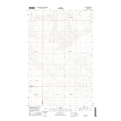
2017 Map of Soo NW
USGS Topo · Published 2017About this map
Wolf Cr and Redstone Cr meander through this northeastern Montana landscape, defining the drainage patterns in a region where the borders of Sheridan County and Daniels County meet. The terrain is characterized by a network of rural routes that follow section lines and topography, including Wolf Creek Rd and S Redstone Rd. These roads provide the primary access to the open range and agricultural tracts divided into townships such as t34n r52e.
Find a feature on this map
15 named features on this map. Tap any name to fly to it.
Don’t see what you’re looking for? This feature index may not catch every label — zoom into the map to look around manually.
Map Details
Editions of this 2017 Soo NW Map
This is the sole edition of this map. No revisions or reprints were ever made.
Other maps of this area

1954 · Wolf Point
USGS Topo · 1:250,000

1958 · Wolf Point
USGS Topo · 1:250,000

1973 · Navajo
USGS Topo · 1:24,000

1973 · Pleasant Prairie
USGS Topo · 1:24,000

1973 · Pleasant Prairie NE
USGS Topo · 1:24,000

1983 · Redstone
USGS Topo · 1:24,000

1983 · Soo NW
USGS Topo · 1:24,000

1983 · Archer
USGS Topo · 1:24,000
1983 · Thornwood Ranch
USGS Topo · 1:24,000
1983 · Soo NE
USGS Topo · 1:24,000