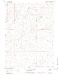
1960 Map of Sooner Reservoir
USGS Topo · Published 1982About this map
Sooner Reservoir lies at the heart of this high desert terrain in Sweetwater, Wyoming, serving as a vital water source in an arid landscape defined by deep ephemeral drainage systems. The map depicts a sparse and specialized human presence during the mid-20th century, notably anchored by the Sheep Camp in the central basin. These seasonal outposts were essential for the regional livestock economy, providing a base for herders navigating the open range. The topography is intricately carved by Battle Spring Draw and Stratton Draw, which guide the flow of seasonal runoff through the sagebrush-covered flats. Originally surveyed in 1960 and updated with 1980 aerial data, the map captures the subtle infrastructure of remote ranching life, from unimproved dirt tracks to small stock reservoirs, before the broader shifts in land use that would follow.
Find a feature on this map
4 named features on this map. Tap any name to fly to it.
Don’t see what you’re looking for? This feature index may not catch every label — zoom into the map to look around manually.
Map Details
Editions of this 1960 Sooner Reservoir Map
2 editions found
Other maps of this area

1954 · Rawlins
USGS Topo · 1:250,000

1955 · Casper
USGS Topo · 1:250,000

1958 · Rawlins
USGS Topo · 1:250,000

1958 · Casper
USGS Topo · 1:250,000

1960 · Battle Spring
USGS Topo · 1:24,000

1960 · Hansen Lake NE
USGS Topo · 1:24,000

1960 · Sooner Reservoir
USGS Topo · 1:24,000

1960 · Larsen Knoll
USGS Topo · 1:24,000

1960 · Hansen Lake
USGS Topo · 1:24,000

1960 · Chicken Spring
USGS Topo · 1:24,000