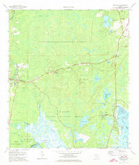
1972 Map of Sopchoppy
USGS Topo · Published 1973About this map
The Sopchoppy River meanders through a landscape defined by the convergence of the Apalachicola National Forest and the St Marks National Wildlife Refuge. This coastal lowlands area in Wakulla County shows the early 1970s balance between the wild terrain of Grimes Bay and small established communities like Sopchoppy, Medart, and Panacea. An Old Railroad Grade cuts through the forest north of Ashmore, tracing a path once vital to the region's timber or turpentine industries.
Find a feature on this map
53 named features on this map. Tap any name to fly to it.
Don’t see what you’re looking for? This feature index may not catch every label — zoom into the map to look around manually.
Map Details
Editions of this 1972 Sopchoppy Map
2 editions found
Other maps of this area

1940 · Arran
USGS Topo · 1:62,500

1943 · Arran
USGS Topo · 1:62,500

1943 · St. Teresa Beach
USGS Topo · 1:24,000

1943 · Lighthouse Point
USGS Topo · 1:24,000

1945 · Bradwell Bay
USGS Topo · 1:31,680

1945 · Lighthouse Point
USGS Topo · 1:31,680

1945 · Mc Intyre
USGS Topo · 1:31,680

1945 · St Teresa
USGS Topo · 1:31,680

1945 · Sanborn
USGS Topo · 1:31,680

1949 · Apalachicola
USGS Topo · 1:250,000