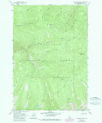
1963 Map of Sourdough Peak
USGS Topo · Published 1987About this map
Sourdough Peak and its surrounding ridgelines dominate this high-elevation interior landscape of central Idaho during the 1960s. The map delineates the administrative boundaries of the Nez Perce National Forest and the Gospel Hump Wilderness, showcasing a terrain defined by steep drainage systems and narrow divides. Named water features like Snoose Creek, Blue Ridge Creek, and Kentucky Creek carve through the deep valleys between heights such as Baking Powder Mountain and Square Mountain. Infrastructure is remarkably sparse, consisting primarily of the Santiam Jeep Trail and primitive wilderness paths. This 1987 update, based on 1963 field checks and 1984 aerial revisions, captures the area's transition into formal wilderness protection, providing a clear record of the backcountry before modern recreation patterns shifted, including the remote Twin Lakes and Moore Lake basins.
Find a feature on this map
27 named features on this map. Tap any name to fly to it.
Don’t see what you’re looking for? This feature index may not catch every label — zoom into the map to look around manually.
Map Details
Editions of this 1963 Sourdough Peak Map
3 editions found
Other maps of this area

1931 · Buffalo Hump
USGS Topo · 1:125,000

1934 · Buffalo Hump
USGS Topo · 1:125,000

1956 · Elk City
USGS Topo · 1:250,000

1960 · Elk City
USGS Topo · 1:250,000

1962 · Golden
USGS Topo · 1:24,000

1963 · Sourdough Peak
USGS Topo · 1:24,000

1963 · Hanover Mtn.
USGS Topo · 1:24,000

1963 · Huddleson Bluff
USGS Topo · 1:24,000

1963 · Marble Butte
USGS Topo · 1:24,000
1963 · Hungry Ridge
USGS Topo · 1:24,000