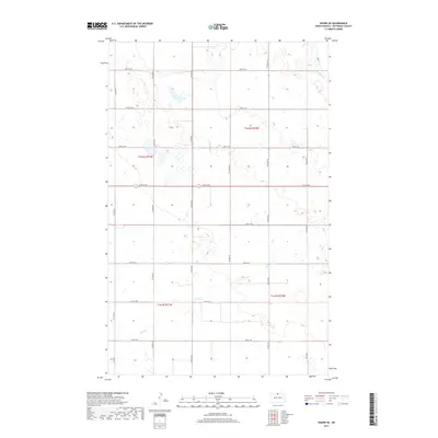
2017 Map of Souris SE
USGS Topo · Published 2017About this map
Stone Cr meanders through this portion of Bottineau County, defining the drainage patterns across a landscape characterized by its systematic township and range organization. This 2017 survey shows the enduring geometry of the rural North Dakota grid, where section lines are traced by an extensive network of local roads such as 100th St NE and 97th St NE. The map illustrates a contemporary rural environment where agriculture and water management are primary influences on the land. Without a central townsite, the map focuses on the distributed network of section corners and north-south corridors like 4th Ave NE and 9th Ave NE, providing a clear record of property divisions and transport routes that have remained consistent for decades in this prairie region.
Find a feature on this map
19 named features on this map. Tap any name to fly to it.
Don’t see what you’re looking for? This feature index may not catch every label — zoom into the map to look around manually.
Map Details
Editions of this 2017 Souris SE Map
This is the sole edition of this map. No revisions or reprints were ever made.
Other maps of this area

1949 · Kramer
USGS Topo · 1:24,000

1950 · Kramer
USGS Topo · 1:24,000

1954 · Souris SW
USGS Topo · 1:24,000

1954 · Souris
USGS Topo · 1:24,000

1954 · Souris SE
USGS Topo · 1:24,000

1954 · Gardena
USGS Topo · 1:24,000

1954 · Minot
USGS Topo · 1:250,000
1955 · Upham NE
USGS Topo · 1:24,000

1955 · Bottineau
USGS Topo · 1:24,000

1956 · Carbury
USGS Topo · 1:24,000