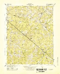
1944 Map of South Anna
USGS Topo · Published 1944About this map
The South Anna River winds through the borderlands of Louisa County and Goochland County, defining a rural Virginia landscape during the mid-1940s. The region is characterized by small post offices and community hubs such as Southanna P O and the crossroad settlement of Gum Spring. This era of development is marked by local industry and infrastructure, notably the Bushee & Son Mill and the Jackson Memorial School, which served the surrounding families. The map also records early geodetic markers like the USC&GS LO Tower 1941, reflecting the surveying efforts of the War Department and Army Corps of Engineers. Natural drainages like Big Lickinghole Creek and Deep Creek carve through the terrain, connecting disparate hamlets like East Leake and Othma within a traditional Piedmont agricultural network.
Find a feature on this map
22 named features on this map. Tap any name to fly to it.
Don’t see what you’re looking for? This feature index may not catch every label — zoom into the map to look around manually.
Map Details
Editions of this 1944 South Anna Map
This is the sole edition of this map. No revisions or reprints were ever made.
Other maps of this area

1890 · Goochland
USGS Topo · 1:125,000

1891 · Palmyra
USGS Topo · 1:125,000

1892 · Goochland
USGS Topo · 1:125,000

1895 · Palmyra
USGS Topo · 1:125,000

1897 · Palmyra
USGS Topo · 1:125,000

1942 · Pendleton
USGS Topo · 1:24,000

1942 · Buckner
USGS Topo · 1:24,000

1943 · Goochland
USGS Topo · 1:31,680

1943 · Perkinsville
USGS Topo · 1:31,680

1943 · Pendleton
USGS Topo · 1:31,680