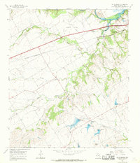
1965 Map of South Bosque
USGS Topo · Published 1969About this map
Lake Waco and the confluence of the Middle Bosque River and South Bosque River define the northern landscape of this mid-1960s survey. The area shows a transition from rural agricultural land to early suburban development, particularly around Woodway. Transport and infrastructure are prominent, with the St Louis Southwestern railroad cutting a straight line across the prairie toward the Mc Gregor Municipal Airfield in the west.
Find a feature on this map
22 named features on this map. Tap any name to fly to it.
Don’t see what you’re looking for? This feature index may not catch every label — zoom into the map to look around manually.
Map Details
Editions of this 1965 South Bosque Map
3 editions found
Other maps of this area

1892 · Temple
USGS Topo · 1:125,000

1892 · Waco
USGS Topo · 1:125,000

1920 · Waco
USGS Topo · 1:125,000

1924 · Waco 4-c
USGS Topo · 1:48,000

1924 · Waco 3-d
USGS Topo · 1:48,000

1924 · Temple 2-C
USGS Topo · 1:48,000

1931 · Valley Mills
USGS Topo · 1:62,500

1931 · Elm Mott
USGS Topo · 1:62,500

1931 · Mc Gregor
USGS Topo · 1:62,500

1954 · Waco
USGS Topo · 1:250,000