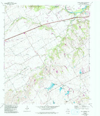
1965 Map of South Bosque
USGS Topo · Published 1993About this map
The South Bosque River corridor southwest of Waco reveals a landscape transitioning from rural agricultural tracts to suburban expansion during the mid-to-late twentieth century. The small community of South Bosque sits at the nexus of the river and rail lines, while to the south, Spring Valley anchors a region defined by the headwaters of North Fork Cow Bayou. For those tracing local genealogy or land use, the Horne Cem and Harris Creek Ch provide essential cultural landmarks among the undulating terrain. Transportation history is visible through an Old Grade and Railroad Grade, indicating the shifting paths of commerce. This 1965 survey, updated with 1990 aerial photography, also documents the development of the McGregor Municipal Airport and the recreational footprint of the Val Verde Waco Campfire Girls Camp near Harris Creek.
Find a feature on this map
29 named features on this map. Tap any name to fly to it.
Don’t see what you’re looking for? This feature index may not catch every label — zoom into the map to look around manually.
Map Details
Editions of this 1965 South Bosque Map
3 editions found
Other maps of this area

1892 · Temple
USGS Topo · 1:125,000

1892 · Waco
USGS Topo · 1:125,000

1920 · Waco
USGS Topo · 1:125,000

1924 · Waco 4-c
USGS Topo · 1:48,000

1924 · Waco 3-d
USGS Topo · 1:48,000

1924 · Temple 2-C
USGS Topo · 1:48,000

1931 · Valley Mills
USGS Topo · 1:62,500

1931 · Elm Mott
USGS Topo · 1:62,500

1931 · Mc Gregor
USGS Topo · 1:62,500

1954 · Waco
USGS Topo · 1:250,000