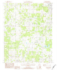
1983 Map of South Fork
USGS Topo · Published 1984About this map
Spring Creek and South Fork Spring River dominate the drainage patterns of this Ozark plateau region as it appeared in the early 1980s. The landscape is dotted with small rural communities and local landmarks, including the namesake settlement of South Fork and the crossroad locales of Burton and Homeland. The social fabric of the era is evident through several small country churches such as Hope Rest Ch, Center of God Ch, and Pleasant Hill Ch.
Find a feature on this map
20 named features on this map. Tap any name to fly to it.
Don’t see what you’re looking for? This feature index may not catch every label — zoom into the map to look around manually.
Map Details
Editions of this 1983 South Fork Map
This is the sole edition of this map. No revisions or reprints were ever made.
Other maps of this area

1938 · West Plains
USGS Topo · 1:24,000

1939 · Topaz
USGS Topo · 1:62,500

1940 · West Plains
USGS Topo · 1:24,000

1941 · Topaz
USGS Topo · 1:62,500

1944 · West Plains
USGS Topo · 1:62,500

1944 · Cureall
USGS Topo · 1:62,500

1945 · Harrison
USGS Topo · 1:250,000

1945 · Willow Springs
USGS Topo · 1:62,500

1946 · West Plains
USGS Topo · 1:62,500

1946 · Cureall
USGS Topo · 1:62,500