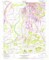
1948 Map of South Fort Smith
USGS Topo · Published 1978About this map
The Arkansas River and Poteau River define this borderland landscape, where industrial expansion meets the foothills of the Ouachita Mountains. Urban development in South Fort Smith is captured at a point of significant growth, with 1970s revisions showing the spreading footprint of residential streets and the Fort Smith Municipal Airport. The industrial character of the era is evident through a strip mine, a saw mill, and a conveyor belt system near the rail lines.
Find a feature on this map
46 named features on this map. Tap any name to fly to it.
Don’t see what you’re looking for? This feature index may not catch every label — zoom into the map to look around manually.
Map Details
Editions of this 1948 South Fort Smith Map
3 editions found
Other maps of this area

1879 · Fort Smith
USGS Topo · 1:62,500

1887 · Van Buren
USGS Topo · 1:62,500

1887 · Greenwood
USGS Topo · 1:62,500

1890 · Fort Smith
USGS Topo · 1:125,000

1900 · Sallisaw
USGS Topo · 1:125,000

1911 · Sallisaw
USGS Topo · 1:125,000

1943 · Fort Smith
USGS Topo · 1:125,000

1946 · Fort Smith
USGS Topo · 1:250,000

1947 · Van Buren
USGS Topo · 1:62,500

1947 · Greenwood
USGS Topo · 1:62,500