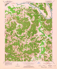
1953 Map of South Hill
USGS Topo · Published 1965About this map
Muddy Creek and the Green River carve through the landscape of Butler County, defining a region where mid-century agriculture and extraction met. During this 1950s survey, the area was dotted with small settlements like Provo, Mining City, and Silver City, many anchored by local family cemeteries such as Rone Cem and Browns Cem. The map reveals a community-focused geography, with numerous rural schools including Oak Grove Sch and Beech Grove Sch serving the local population. Industrial activity is clearly marked by an expansive Oil Field and multiple Strip Mines, particularly near Dunbar. This documentation of the land shows the intricate network of secondary roads connecting these resource-rich hills to river bends like Little Bend, illustrating the transitional economy of rural Kentucky as it balanced traditional farming with growing industrial mining and oil production.
Find a feature on this map
39 named features on this map. Tap any name to fly to it.
Don’t see what you’re looking for? This feature index may not catch every label — zoom into the map to look around manually.
Map Details
Editions of this 1953 South Hill Map
2 editions found
Other maps of this area

1909 · Hartford
USGS Topo · 1:62,500

1911 · Dunmor
USGS Topo · 1:48,000

1914 · Little Muddy
USGS Topo · 1:62,500

1914 · Dunmor
USGS Topo · 1:62,500

1925 · Spring Lick
USGS Topo · 1:62,500

1953 · Dunmor
USGS Topo · 1:24,000

1953 · South Hill
USGS Topo · 1:24,000

1953 · Quality
USGS Topo · 1:24,000

1953 · Rochester
USGS Topo · 1:24,000

1954 · Evansville
USGS Topo · 1:250,000