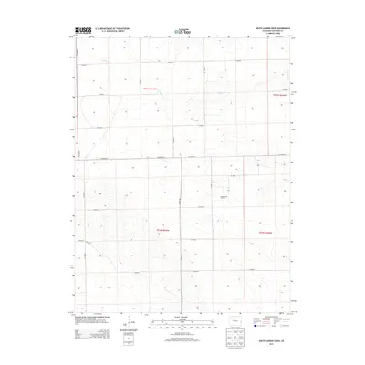
2013 Map of South Ladder Creek
USGS Topo · Published 2013About this map
The Golden Spike Oil Field stands as a primary point of interest in this section of Cheyenne County, marking the industrial footprint of energy extraction within the Great Plains. The landscape is defined by the ephemeral path of S Ladder Cr, which cuts through the high plains terrain, and a strictly organized section-line grid of rural roads. This network, including Co Highway G and Co Hwy 40, illustrates the methodical settlement and land management patterns characteristic of eastern Colorado. The map captures the intersection of traditional agricultural land divisions with modern resource development, providing a clear view of the area's geographic organization and sparse infrastructure.
Find a feature on this map
21 named features on this map. Tap any name to fly to it.
Don’t see what you’re looking for? This feature index may not catch every label — zoom into the map to look around manually.
Map Details
Editions of this 2013 South Ladder Creek Map
This is the sole edition of this map. No revisions or reprints were ever made.
Other maps of this area

1891 · Kit Carson
USGS Topo · 1:125,000

1892 · Cheyenne Wells
USGS Topo · 1:125,000

1893 · Kit Carson
USGS Topo · 1:125,000

1894 · Cheyenne Wells
USGS Topo · 1:125,000

1954 · Lamar
USGS Topo · 1:250,000

1958 · Lamar
USGS Topo · 1:250,000

1981 · Cheyenne Wells
USGS Topo · 1:100,000
1982 · Kit Carson 4 SE
USGS Topo · 1:24,000

1982 · Cheyenne Wells SW
USGS Topo · 1:24,000

1982 · Kit Carson 4 NE
USGS Topo · 1:24,000