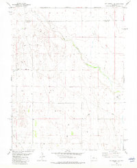
1982 Map of Kit Carson 4 SE
USGS Topo · Published 1982About this map
Big Sandy Creek and Rush Creek carve their paths through this high plains landscape on the border of Cheyenne and Kiowa Counties. The terrain is defined by its industrial and utilitarian infrastructure in the early 1980s, featuring an extensive Pipeline network and an Aqueduct that underscores the region's managed water resources. A Pumping Sta and a set of Landing Strips highlight the functional nature of this rural stretch of Colorado, where agricultural and resource needs dictate the few visible landmarks. This 1982 edition captures a quiet moment in eastern Colorado, reflecting a period of established ranching and infrastructure before subsequent modern developments changed the local footprint.
Find a feature on this map
7 named features on this map. Tap any name to fly to it.
Don’t see what you’re looking for? This feature index may not catch every label — zoom into the map to look around manually.
Map Details
Editions of this 1982 Kit Carson 4 SE Map
2 editions found
Other maps of this area

1890 · Granada
USGS Topo · 1:125,000

1891 · Kit Carson
USGS Topo · 1:125,000

1892 · Lamar
USGS Topo · 1:125,000

1892 · Cheyenne Wells
USGS Topo · 1:125,000

1892 · Granada
USGS Topo · 1:125,000

1893 · Kit Carson
USGS Topo · 1:125,000

1894 · Cheyenne Wells
USGS Topo · 1:125,000

1894 · Granada
USGS Topo · 1:125,000

1954 · Lamar
USGS Topo · 1:250,000

1958 · Lamar
USGS Topo · 1:250,000