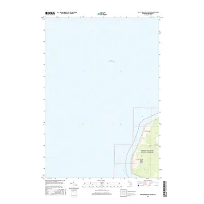
2017 Map of South Manitou Island
USGS Topo · Published 2017About this map
South Manitou Island rises from the deep waters of Lake Michigan, showing the isolated geography of this island before the turn of the decade. The map reveals the eastern shoreline where the land falls within the Sleeping Bear Dunes National Lakeshore. The topography here is defined by high bluffs and internal ridges, with Chicago Rd serving as a primary route through the interior sections. This survey preserves the 2017 boundaries of the national park lands and the specific section lines of the Public Land Survey System, including t30n r15w and t31n r15w. For those studying the maritime history or the preserved wilderness of the Manitou passage, this record documents the coastal contours and the few established paths across the island's varied elevations.
Find a feature on this map
16 named features on this map. Tap any name to fly to it.
Don’t see what you’re looking for? This feature index may not catch every label — zoom into the map to look around manually.
Map Details
Editions of this 2017 South Manitou Island Map
This is the sole edition of this map. No revisions or reprints were ever made.
Other maps of this area

1954 · Escanaba
USGS Topo · 1:250,000

1954 · Manitowoc
USGS Topo · 1:250,000

1956 · North Manitou
USGS Topo · 1:62,500

1957 · Escanaba
USGS Topo · 1:250,000

1957 · Empire
USGS Topo · 1:62,500

1958 · Escanaba
USGS Topo · 1:250,000

1958 · Manitowoc
USGS Topo · 1:250,000
1983 · Glen Haven
USGS Topo · 1:25,000
1983 · South Manitou Island
USGS Topo · 1:24,000

1984 · Washington Island
USGS Topo · 1:100,000