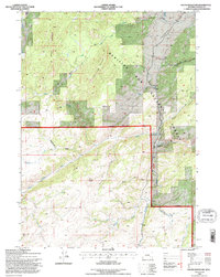
1992 Map of South Mountain
USGS Topo · Published 1996About this map
Medicine Bow National Forest dominates this Albany County landscape, where the North Laramie River winds through high-altitude terrain at the edge of the Laramie Range. The 1992 field check documents a territory defined by complex drainage systems, including the high ridges of South Mountain and Bear Head Mountain. Evidence of ranching and remote land use is centered on the Double Four Ranch near the river's bend, while the backcountry is accessed via the historic Arapaho Trail.
Find a feature on this map
24 named features on this map. Tap any name to fly to it.
Don’t see what you’re looking for? This feature index may not catch every label — zoom into the map to look around manually.
Map Details
Editions of this 1992 South Mountain Map
This is the sole edition of this map. No revisions or reprints were ever made.
Other maps of this area

1943 · Esterbrook
USGS Topo · 1:62,500

1945 · Esterbrook
USGS Topo · 1:62,500

1954 · Torrington
USGS Topo · 1:250,000

1958 · Torrington
USGS Topo · 1:250,000

1964 · Windy Peak
USGS Topo · 1:24,000

1968 · Cow Creek Mountain
USGS Topo · 1:24,000

1968 · Davidson Flats
USGS Topo · 1:24,000
1968 · Reese Mountain
USGS Topo · 1:24,000
1968 · Fletcher Park
USGS Topo · 1:24,000
1968 · South Mountain
USGS Topo · 1:24,000