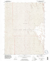
1993 Map of South of Arinosa SE
USGS Topo · Published 1996About this map
The Utah Test and Training Range dominates this landscape, illustrating the mid-to-late 20th-century utilization of the Great Salt Lake Desert for military operations. This 1:24,000 scale survey, revised in the early 1990s, provides a technical view of the low-relief terrain, where the expansive Mud Flat dictates the geography. The map reveals the intricate contouring of an environment where elevation changes are measured in mere feet, showing how military boundaries and public land survey systems were imposed upon this seemingly featureless salt crust. It serves as a precise record of the desert's character before modern navigational technologies shifted the focus of such remote interior basins.
Find a feature on this map
4 named features on this map. Tap any name to fly to it.
Don’t see what you’re looking for? This feature index may not catch every label — zoom into the map to look around manually.
Map Details
Editions of this 1993 South of Arinosa SE Map
This is the sole edition of this map. No revisions or reprints were ever made.
Other maps of this area

1953 · Tooele
USGS Topo · 1:250,000

1955 · Tooele
USGS Topo · 1:250,000

1973 · Knolls SW
USGS Topo · 1:24,000

1973 · Arinosa SE
USGS Topo · 1:24,000

1973 · Arinosa SW
USGS Topo · 1:24,000

1973 · Wildcat Mountain SW
USGS Topo · 1:24,000

1973 · Wildcat Mountain NW
USGS Topo · 1:24,000

1973 · Gold Hill 1 SE
USGS Topo · 1:24,000

1973 · Gold Hill 1 SW
USGS Topo · 1:24,000

1973 · Gold Hill 1 NE
USGS Topo · 1:24,000