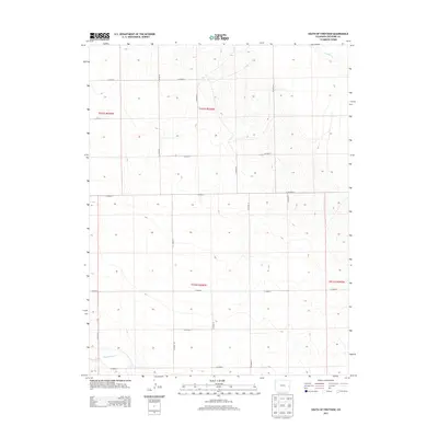
2013 Map of South of Firstview
USGS Topo · Published 2013About this map
Big Sandy Cr winds through the southwestern corner of this Cheyenne County landscape, part of a high plains drainage system that defines the local topography. This 2013 survey illustrates the rigid geometric precision of the Public Land Survey System, where a network of section lines and county roads, such as Co Road K and Co Road B, carve the open prairie into distinct townships. The map covers the intersection of four major survey blocks, including t015s r046w and t016s r046w, showcasing how early land division continues to dictate modern transit and property boundaries. While largely agricultural, the terrain is marked by subtle elevation changes near S Ladder Cr in the northeast, providing essential water drainage for the surrounding ranchlands. The road network, featuring Co Highway G, highlights the primary transportation corridors connecting this rural area to the broader region.
Find a feature on this map
20 named features on this map. Tap any name to fly to it.
Don’t see what you’re looking for? This feature index may not catch every label — zoom into the map to look around manually.
Map Details
Editions of this 2013 South of Firstview Map
This is the sole edition of this map. No revisions or reprints were ever made.
Other maps of this area

1891 · Kit Carson
USGS Topo · 1:125,000

1892 · Cheyenne Wells
USGS Topo · 1:125,000

1893 · Kit Carson
USGS Topo · 1:125,000

1894 · Cheyenne Wells
USGS Topo · 1:125,000

1954 · Lamar
USGS Topo · 1:250,000

1958 · Lamar
USGS Topo · 1:250,000

1981 · Cheyenne Wells
USGS Topo · 1:100,000
1982 · Kit Carson 4 SE
USGS Topo · 1:24,000

1982 · Cheyenne Wells SW
USGS Topo · 1:24,000

1982 · Kit Carson 4 NE
USGS Topo · 1:24,000