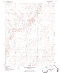
1979 Map of South of Flagler
USGS Topo · Published 1995About this map
The South Fork Republican River cuts through the High Plains landscape of eastern Colorado, defining the central hydrology of this Kit Carson Co. region. Compiled from mid-1970s aerial photography, the map reveals a sparsely populated ranching and agricultural territory characterized by wide drainages and intermittent water sources. The meandering paths of Sand Creek and Spring Creek join the river system, reflecting the area's dependence on seasonal flow and groundwater management.
Find a feature on this map
7 named features on this map. Tap any name to fly to it.
Don’t see what you’re looking for? This feature index may not catch every label — zoom into the map to look around manually.
Map Details
Editions of this 1979 South of Flagler Map
2 editions found
Other maps of this area

1954 · Limon
USGS Topo · 1:250,000

1957 · Limon
USGS Topo · 1:250,000

1958 · Limon
USGS Topo · 1:250,000

1978 · Hugo 4 NW
USGS Topo · 1:24,000

1979 · Hugo 4 NE
USGS Topo · 1:24,000

1979 · Flagler SW
USGS Topo · 1:24,000

1979 · Flagler
USGS Topo · 1:24,000
1979 · Hugo 4 SE
USGS Topo · 1:24,000
1979 · Hugo 4 NW
USGS Topo · 1:24,000
1979 · Stratton 3 SW
USGS Topo · 1:24,000