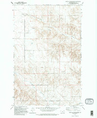
1973 Map of South of Four Buttes
USGS Topo · Published 1995About this map
The Fort Peck Indian Reservation dominates the southern portion of this landscape, its northern boundary demarcating a transition in the ranching and agricultural terrain of Daniels County. The land is defined by a series of intermittent drainages and deep coulees, including Negro Coulee and Cabarett Coulee, which snake across the plains toward the southern reaches of the quadrangle. These waterways, alongside Police Creek, provided essential drainage in an area where local water sources like several named Springs were critical for sustaining early livestock operations.
Find a feature on this map
10 named features on this map. Tap any name to fly to it.
Don’t see what you’re looking for? This feature index may not catch every label — zoom into the map to look around manually.
Map Details
Editions of this 1973 South of Four Buttes Map
2 editions found
Other maps of this area

1954 · Wolf Point
USGS Topo · 1:250,000

1958 · Wolf Point
USGS Topo · 1:250,000

1973 · Peerless 4 NE
USGS Topo · 1:24,000

1973 · Scobey
USGS Topo · 1:24,000

1973 · Nielsen Coulee
USGS Topo · 1:24,000

1973 · Killenbeck Reservoir
USGS Topo · 1:24,000

1973 · Cabarett Coulee
USGS Topo · 1:24,000

1973 · Peerless 4 SE
USGS Topo · 1:24,000

1973 · Peerless 4 SW
USGS Topo · 1:24,000

1973 · Four Buttes
USGS Topo · 1:24,000