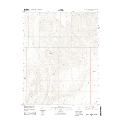
2015 Map of South of Gregerson Basin
USGS Topo · Published 2015About this map
The Delamar Mountains dominate this 2015 topography of Lincoln County, defining a landscape of high-elevation basins and seasonal water sources. The map provides a detailed view of the water management infrastructure in this arid region, from the Pony Reservoir in the north to the Pocket Number Three Reservoir further south. These catchments, along with Gregerson Basin Number Two, underscore the significance of every named water feature in the Great Basin environment. Access to these remote elevations is traced via Bomber Rd and Pony Reservoir Rd, which navigate the complex terrain leading toward the Kane Springs Valley. The inclusion of Wire Grass Spring suggests a point of perennial importance for local ecology and historical land use in an otherwise dry mountain range.
Find a feature on this map
14 named features on this map. Tap any name to fly to it.
Don’t see what you’re looking for? This feature index may not catch every label — zoom into the map to look around manually.
Map Details
Editions of this 2015 South of Gregerson Basin Map
This is the sole edition of this map. No revisions or reprints were ever made.
Other maps of this area

1885 · Pioche
USGS Topo · 1:250,000

1886 · Pioche
USGS Topo · 1:250,000

1954 · Caliente
USGS Topo · 1:250,000

1959 · Caliente
USGS Topo · 1:250,000

1969 · Vigo NW
USGS Topo · 1:24,000
1969 · Delamar 3 SE
USGS Topo · 1:24,000

1969 · Gregerson Basin
USGS Topo · 1:24,000

1969 · Delamar 3 NE
USGS Topo · 1:24,000
1969 · Delamar 3 SW
USGS Topo · 1:24,000
1969 · Sunflower Mtn
USGS Topo · 1:24,000