
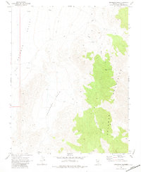
1969 Map of Gregerson Basin
USGS Topo · Published 1973About this map
Delamar Mountains dominate the eastern reaches of this 1969 field-checked survey, creating a dramatic topographical divide in Lincoln County. To the west, the landscape drops into the broad Gregerson Basin and the expansive Delamar Valley, reflecting the classic basin-and-range geography of southern Nevada. Evidence of remote ranching and land use is present through the identification of a Corral and two vital Water Tanks positioned to catch runoff in this arid environment.
Find a feature on this map
9 named features on this map. Tap any name to fly to it.
Don’t see what you’re looking for? This feature index may not catch every label — zoom into the map to look around manually.
Map Details
Editions of this 1969 Gregerson Basin Map
2 editions found
Other maps of this area

1885 · Pioche
USGS Topo · 1:250,000

1886 · Pioche
USGS Topo · 1:250,000

1954 · Caliente
USGS Topo · 1:250,000

1959 · Caliente
USGS Topo · 1:250,000

1969 · Vigo NW
USGS Topo · 1:24,000

1969 · Delamar
USGS Topo · 1:24,000

1969 · Delamar 3 NE
USGS Topo · 1:24,000
1969 · Delamar 3 NW
USGS Topo · 1:24,000

1969 · Slidy Mountain
USGS Topo · 1:24,000

1969 · Delamar NW
USGS Topo · 1:24,000