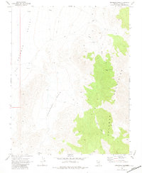
1969 Map of Gregerson Basin
USGS Topo · Published 1981About this map
Gregerson Basin sits at the heart of this late-1960s landscape, serving as a low-lying transition between the high ridges of the Delamar Mountains and the broad expanse of Delamar Valley to the west. Human presence is sparse, marked primarily by a network of seasonal water sources and transit paths. Water, the most precious resource in this arid Lincoln County environment, is carefully mapped at Jumbo Spring, Pony Reservoir, and various tanks. The topography reveals a rugged interior accessible only by a primitive Jeep Trail, which winds through the mountain passes and follows the course of Jumbo Wash. This survey captures the region just as photogrammetric mapping began to provide high-resolution detail of these remote basins, documenting the stock-watering infrastructure and trails used by local ranchers and land managers in the mid-20th century.
Find a feature on this map
8 named features on this map. Tap any name to fly to it.
Don’t see what you’re looking for? This feature index may not catch every label — zoom into the map to look around manually.
Map Details
Editions of this 1969 Gregerson Basin Map
2 editions found
Other maps of this area

1885 · Pioche
USGS Topo · 1:250,000

1886 · Pioche
USGS Topo · 1:250,000

1954 · Caliente
USGS Topo · 1:250,000

1959 · Caliente
USGS Topo · 1:250,000

1969 · Vigo NW
USGS Topo · 1:24,000

1969 · Delamar
USGS Topo · 1:24,000

1969 · Gregerson Basin
USGS Topo · 1:24,000

1969 · Delamar 3 NE
USGS Topo · 1:24,000
1969 · Delamar 3 NW
USGS Topo · 1:24,000

1969 · Slidy Mountain
USGS Topo · 1:24,000