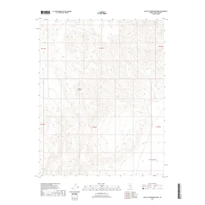
2018 Map of South of Gregerson Basin
USGS Topo · Published 2018About this map
Delamar Mountains dominate the central topography of this Lincoln County landscape, defining the high ground between desert basins. In the northern reaches, the Pony Reservoir provides a rare collection point for seasonal runoff within the arid high-desert environment. The eastern portion of the sheet opens into the broad expanse of Kane Springs Valley, illustrating the typical basin-and-range geography of southeastern Nevada. This 2018 survey by the U.S. Geological Survey maps a largely undeveloped wilderness, where land use is primarily defined by the Public Land Survey System grid, including townships t8s r64e and t9s r64e. The map serves as a contemporary record of the area's drainage patterns and topographic relief before any significant modern encroachment.
Find a feature on this map
9 named features on this map. Tap any name to fly to it.
Don’t see what you’re looking for? This feature index may not catch every label — zoom into the map to look around manually.
Map Details
Editions of this 2018 South of Gregerson Basin Map
This is the sole edition of this map. No revisions or reprints were ever made.
Other maps of this area

1885 · Pioche
USGS Topo · 1:250,000

1886 · Pioche
USGS Topo · 1:250,000

1954 · Caliente
USGS Topo · 1:250,000

1959 · Caliente
USGS Topo · 1:250,000

1969 · Vigo NW
USGS Topo · 1:24,000
1969 · Delamar 3 SE
USGS Topo · 1:24,000

1969 · Gregerson Basin
USGS Topo · 1:24,000

1969 · Delamar 3 NE
USGS Topo · 1:24,000
1969 · Delamar 3 SW
USGS Topo · 1:24,000
1969 · Sunflower Mtn
USGS Topo · 1:24,000