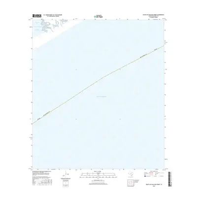
2016 Map of South of Palacios Point
USGS Topo · Published 2016About this map
The vast expanse of the Gulf of Mexico dominates this coastal survey, where the maritime boundaries of Matagorda County stretch across the open water. This 2016 record focuses on the transition between the inner bays and the sea, highlighting the essential maritime corridor of the Intracoastal Waterway as it bypasses the northern reaches of the quadrangle. The map captures the delicate interface of the Texas shoreline near Matagorda Bay and the natural inlet of Greens Bayou, documenting the coastal topography at a time of modern navigational reliance. While largely offshore, the map provides a precise legal and geodetic reference for the county's territorial waters and the vital shipping routes that define the Gulf Coast economy.
Find a feature on this map
6 named features on this map. Tap any name to fly to it.
Don’t see what you’re looking for? This feature index may not catch every label — zoom into the map to look around manually.
Map Details
Editions of this 2016 South of Palacios Point Map
This is the sole edition of this map. No revisions or reprints were ever made.
Other maps of this area

1952 · Palacios SE
USGS Topo · 1:24,000

1952 · Palacios Point
USGS Topo · 1:24,000

1952 · South of Palacios Point
USGS Topo · 1:24,000

1952 · Decros Point
USGS Topo · 1:24,000

1953 · Beeville
USGS Topo · 1:250,000

1956 · Beeville
USGS Topo · 1:250,000

1960 · Beeville
USGS Topo · 1:250,000
1980 · Carancahua Pass
USGS Topo · 1:24,000
1983 · San Antonio Bay
USGS Topo · 1:100,000
1984 · Port Lavaca
USGS Topo · 1:100,000