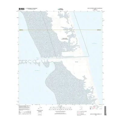
2016 Map of South of Potrero Lopeno SE
USGS Topo · Published 2016About this map
Padre Island National Seashore dominates this coastal survey, where the barrier island meets the open waters of the Gulf of Mexico. The map details the delicate shoreline and sand-dune environment of Padre Island as it appeared in the mid-2010s, bisected by the Port Mansfield Channel. This artificial waterway serves as a critical passage between the inner lagoon and the gulf, defining the southern navigational limits of the immediate area. The boundary line for Kenedy Co and Willacy Co is shown crossing the northern stretch of the island, providing a precise marker for researchers tracking land jurisdiction or historical property boundaries along this shifting maritime landscape.
Find a feature on this map
5 named features on this map. Tap any name to fly to it.
Don’t see what you’re looking for? This feature index may not catch every label — zoom into the map to look around manually.
Map Details
Editions of this 2016 South of Potrero Lopeno SE Map
This is the sole edition of this map. No revisions or reprints were ever made.
Other maps of this area

1951 · South of Potrero Lopeno NE
USGS Topo · 1:24,000

1952 · Green Island
USGS Topo · 1:24,000

1952 · South of Potrero Lopeno NW
USGS Topo · 1:24,000
1952 · North Of Port Isabel NW
USGS Topo · 1:24,000

1952 · South of Potrero Lopeno SE
USGS Topo · 1:24,000

1952 · Hawk Island
USGS Topo · 1:24,000

1952 · Port Mansfield
USGS Topo · 1:24,000

1952 · South of Potrero Lopeno
USGS Topo · 1:62,500

1953 · Brownsville
USGS Topo · 1:250,000
1955 · La Leona
USGS Topo · 1:62,500