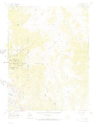
1961 Map of South Peak
USGS Topo · Published 1968About this map
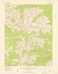
High-altitude mining operations concentrate on the western slopes of the San Isabel National Forest, where a cluster of deep shafts suggests a legacy of intense silver or gold extraction. Notable excavations including the Yosemite shaft, California Tunnel, and the Yankee Blade shaft are situated near Low Pass Gulch, illustrating the industrial footprint on this mountain landscape. The topography transitions sharply from the 12,892-foot summit of South Peak down toward the Arkansas River valley.
Find a feature on this map
39 named features on this map. Tap any name to fly to it.
Don’t see what you’re looking for? This feature index may not catch every label — zoom into the map to look around manually.
Map Details
Editions of this 1961 South Peak Map
3 editions found
Other maps of this area

1889 · Leadville
USGS Topo · 1:125,000

1891 · Leadville
USGS Topo · 1:125,000
1935 · Mount Elbert
USGS Topo · 1:62,500

1938 · Mount Elbert
USGS Topo · 1:62,500

1939 · Mount Elbert
USGS Topo · 1:62,500

1942 · Leadville
USGS Topo · 1:125,000
1955 · Buena Vista
USGS Topo · 1:62,500
1955 · Mount Harvard
USGS Topo · 1:62,500

1956 · Montrose
USGS Topo · 1:250,000

1957 · Leadville
USGS Topo · 1:250,000