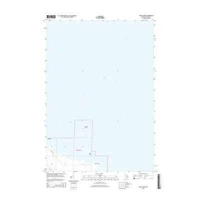
2014 Map of South Point
USGS Topo · Published 2014About this map
Lake Huron and the waters of Thunder Bay dominate this coastal landscape on the edge of Alpena County. The shoreline is defined by the sharp protrusion of South Point, which marks the transition between the open lake and the protected bay. Scattered just offshore are small landforms such as Scarecrow Island and Bird Island, while Hardwood Point frames the northern reaches of the bay. Inland, the map reveals a sparsely developed area within t29n r9e of the Public Land Survey System. The infrastructure is limited to local connectors like Brousseau Rd and Wilds Rd, reflecting a quiet, rural character focused on the natural interface of the Great Lakes coastline. This 2014 survey documents the exact positioning of these coastal features and the primary roads providing access to the peninsula.
Find a feature on this map
9 named features on this map. Tap any name to fly to it.
Don’t see what you’re looking for? This feature index may not catch every label — zoom into the map to look around manually.
Map Details
Editions of this 2014 South Point Map
This is the sole edition of this map. No revisions or reprints were ever made.
Other maps of this area

1954 · Tawas City
USGS Topo · 1:250,000

1954 · Alpena
USGS Topo · 1:250,000

1957 · Alpena
USGS Topo · 1:250,000

1958 · Alpena
USGS Topo · 1:250,000

1958 · Tawas City
USGS Topo · 1:250,000

1969 · Alpena
USGS Topo · 1:250,000

1971 · Alpena
USGS Topo · 1:24,000
1971 · Thunder Bay Island
USGS Topo · 1:24,000

1971 · Spruce
USGS Topo · 1:24,000

1971 · North Point
USGS Topo · 1:24,000